

About NMRDA
Executive Summary
Nagpur is one of the largest cities in Central India and the third largest city in Maharashtra after Mumbai and Pune. A major commercial and political center of the State, its central location endows it with excellent connectivity offering an opportunity to enhance its economic significance. This coupled with surrounding rich natural resources and availability of ample water render it an attractive destination for future growth. Across the past few years the urban agglomeration has expanded beyond the City's municipal boundaries. This rapid growth has presented challenges for the future growth of the city and its fringes in an organized manner. With a view to achieve balanced development within the region the Nagpur Metropolitan Region Development Authority (NIT) has been notified as a Special Planning Authority (SPA) for the NMA and entrusted with preparation of a Statutory Development Plan as per provisions of the MRTP Act, 1966. The notified Nagpur Metropolitan Area (NMA) comprises of areas outside the Nagpur city. It includes 721 villages under 9 tehsils of the Nagpur District spreading across an area of 3,567 km2. This Draft Development Plan Report is intended to serve as a blueprint for implementing land use and infrastructure proposals in the NMA for a twenty year period from 2012 to 2032. It is based on a 50 year broad vision plan that outlines key strategies conceived through a series of discussions with elected representatives, government and non-government agencies, subject matter experts and inputs from citizens.
Project Area
The Nagpur Metropolitan Area was notified on 23rd July 1999. As per State government notification 726 villages were included in the NMA under 9 tehsils (5 full tehsils – Nagpur Rural, Hingna, Kamptee, Parshioni, Mauda and 4 part tehsils – Saoner, Umred, Kalmeshwar and Kuhi), comprising of 726 villages of the Nagpur District. The total area as per the State Government notification is 3,577.70 sq.km. The NMA covers about 36% of the Nagpur District (9,892 sq.km) and is adjoined by Amravati and Wardha districts on the west, Bhandara District on the east and Chhindwara and Balaghat districts of Madhya Pradesh on the north-west.
Boundary and Extents of the NMA
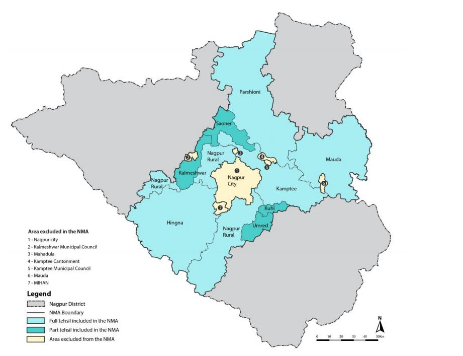
The areas managed by other planning authorities are excluded from the NMA area and are listed below:
- Nagpur City area under Nagpur Municipal Corporation (NMC)
- MIHAN area under Maharashtra Airport Development Company (MADC)
- Industrial areas under Maharashtra Industrial Development Corporation (MIDC)
- Kamptee Cantonment area
- Kamptee Municipal Council area
- Kalmeshwar Municipal Council area
Vision and Goals
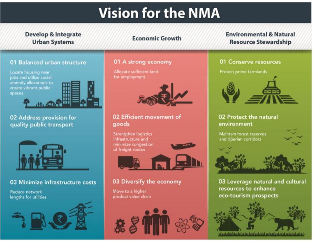
The NMA is a vast area with diverse uses, geographies, and functions. Yet it needs to function as a single entity in order to harness its strengths to create a vibrant centre for trade and commerce. The long-term vision for the NMA is that of a vibrant place that provides a platform for healthy economic growth across the cross-section of the urban-rural transect. This can be achieved by promoting quality urban space, preserving natural resources and farmland, promoting industries, tourism and allied activities, all to provide an even better quality of life to the residents of the region. Fundamentally, there are three working components of the vision – development and integration of urban systems, economic growth, and environmental stewardship.
Areas under Proposed Land Use Zones
| Sr No. | Land use zone | Area (Sq km) | Percent of Urban land | Percent of Total area |
|---|---|---|---|---|
| 1 | Residential | 381.81 | 50.53% | 10.70% |
| 2 | Commercial | 9.03 | 1.19% | 0.24% |
| 3 | Industrial | 101.20 | 13.39% | 2.84% |
| 4 | Public-Semipublic | 61 | 8.08% | 1.71% |
| 5 | Public Utility | 7.91 | 1.05% | 0.22% |
| 6 | Recreation/Open space | 67.98 | 9% | 1.91% |
| 7 | Defense | 23.64 | 3.13% | 0.66% |
| 8 | Transportation | 142.16 | 18.81% | 3.99% |
| 9 | Subtotal Urban | 755.66 | 100% | 21.17% |
| 10 | Hills | 108.62 | 3.04% | |
| 11 | Mines/Quarries | 28.49 | 0.80% | |
| 12 | Agriculture | 2007 | 56.26% | |
| 13 | Forest | 508.46 | 14.25% | |
| 14 | Waterbodies | 228.52 | 6.41% | |
| Total Area | 3567.37 | 100.00% |
Revised number of villages in tehsils included in the NMA
| Sr No. | Tehsil | Number of Villages | Area of Tehsil (km2 ) | % area of Tehsil in NMA |
|---|---|---|---|---|
| 1 | Parshioni | 127 | 762.25 | 21% |
| 2 | Hingna | 164 | 641.07 | 18% |
| 3 | Nagpur (Rural) | 162 | 393.52 | 11% |
| 4 | Mouda | 123 | 815.19 | 23% |
| 5 | Kamptee | 77 | 617.24 | 17% |
| 6 | Saoner(part) | 27 | 125.1 | 4% |
| 7 | Umred(part) | 13 | 75.1 | 2% |
| 8 | Kuhi (Part) | 7 | 34.8 | 1% |
| Total Area | 721 | 3567.37 | 100% |